
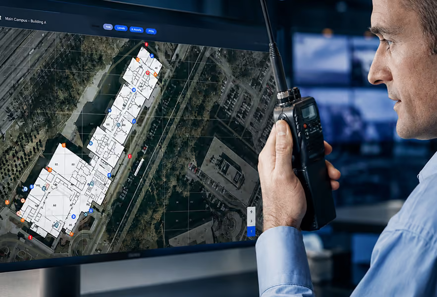
When help arrives at a school, how do responders know where to go?
Former Delaware Governor Jack Markell recalls that question as a foundational challenge in his state’s school emergency preparedness work. Schools needed to make their layouts accessible to the people who might be summoned during an emergency.
In Episode 10 of The Safety Signal, “Show Me the Money. Promises Don’t Make Schools Safe,” Markell joins CENTEGIX CMO Robb Monkman to discuss what it takes to turn school safety commitments into practical protection.
His account illustrates a need that critical incident mapping addresses today: giving school teams and responders usable building information so they can understand the location of an emergency and the resources around it.
What preparedness gap did Markell describe in Delaware?
Monkman asks Markell about House Bill 340, signed in 2014. The Delaware General Assembly’s bill summary explains that it accelerated the compliance deadline under the existing Omnibus School Safety Act and revised exercise requirements. A state announcement at the time described the push for comprehensive, current school safety plans.
Markell’s recollection focuses on a concrete response need. The state lacked sufficient awareness of school interiors and how to communicate that information to first responders.
He describes making school layouts available on responders’ devices so that, when they arrived, “they knew exactly where they were going.”
That information mattered before anyone entered the building. A responder unfamiliar with a campus needed a way to understand its layout without relying entirely on someone’s verbal directions during the incident.
“That is at the very bottom layer of what’s required,” Markell says. “There’s so much more now that we know that can be done.” That starting point remains relevant as mapping technology advances: responders must be able to understand the place where help is needed.
Why do responders need more than a school’s address?
An address directs responders to a property. A school emergency may require them to reach a particular floor, room, entrance, or outdoor area within that property.
That distinction becomes important on campuses with multiple buildings, athletic facilities, or spaces that people describe differently. School staff may know a room by its everyday name while responders are working from a numbered floor plan.
Clear incident location and facility context help teams establish a shared reference. Digital mapping can also show nearby safety equipment and access points, giving responders information they can use as they assess the situation.
The federal school emergency operations planning guide emphasizes collaboration with first responders and tailoring plans to each building. Mapping supports that work by making the physical setting easier to understand.
For example, in a medical emergency, designated responders may need to find both the person requesting help and an AED. During an evacuation, teams need to understand routes and designated locations. The map should support the actions described in the school’s procedures.
This is the practical value of digital mapping that brings clarity to emergency response: people can work from the same view of the campus rather than reconstructing it during an incident.
How does digital mapping connect layouts with emergency information?
School layouts provide the setting. Incident information identifies what is happening within that setting.
Later in the episode, Markell discusses tools available to schools today. He highlights the ability to communicate “the nature of the emergency, the location of the emergency” to first responders in real time. He also mentions video as a way to show what is occurring in some situations.
Those observations connect his earlier mapping story to a broader response need. Teams benefit from understanding both the facility and the current incident.
CENTEGIX Safety Blueprint® provides digital campus and safety asset maps that authorized users can update. When connected with CENTEGIX CrisisAlert™, the system can display an alert’s location to help responders identify where assistance is needed.
Where configured, Alert Activated Video can add visual context. Different activation pathways and workflows should be evaluated against the district’s response procedures, including how video connects with incident detection and response.
The CISA K–12 School Security Guide encourages a systems-based approach to physical security. Mapping belongs within that larger approach, connected to the people, procedures, and technologies responsible for responding.
What makes incident mapping useful to emergency partners?
Useful mapping requires accurate information, access for the intended responders, and a shared understanding of how to use it.
The National 911 Program’s GIS assessment identifies data maintenance and sharing as important to Next Generation 911. Its findings provide broader context for why location data must remain usable across participating organizations.
School leaders should work with local responders to confirm how campus information will be accessed and interpreted. A map available to the school’s internal safety team is not automatically available within every external dispatch workflow. Those connections require coordination and verification.
Districts can ask:
- Are room names, building labels, and entrances consistent with what responders will see onsite?
- Who updates maps when rooms, facilities, or safety assets change?
- Can authorized response partners access the information through the agreed workflow?
- Have teams practiced using the maps during an exercise?
FEMA’s exercise improvement guidance explains how exercises help evaluate capabilities and identify corrective actions. A drill can reveal an outdated room label, an access problem, or uncertainty about where an alert appears. Assigning responsibility for those corrections helps preserve readiness.
Map access and accuracy also connect to reducing delays across emergency response. The benefit depends on whether information reaches the people who need it in time to act.
Why does mapping require an ongoing commitment?
Markell recalls that making layouts available to responders took considerable work and resources. His broader funding argument applies here as well: preparedness requires a commitment that continues after a requirement is announced.
Building information changes. Schools renovate spaces, relocate equipment, and adjust room assignments. Mapping responsibilities should be included in a school safety plan, with a process for checking information and sharing updates with the right partners.
The Delaware Department of Education describes school safety planning through prevention and mitigation, preparedness, response, and recovery. That scope reinforces why building information matters during planning and practice as well as during an incident.
Markell’s story starts with school layouts, but its lesson extends to every stage of preparedness. Information must be available in a form people can use, and schools need resources to keep it useful.
Hear Markell describe Delaware’s preparedness work and the information responders need in Episode 10 of The Safety Signal, “Show Me the Money. Promises Don’t Make Schools Safe.”
Frequently asked questions about critical incident mapping
What is critical incident mapping?
Critical incident mapping organizes facility and safety information into maps used for planning and emergency response. Depending on the solution, it can show building layouts, room labels, entrances, evacuation locations, safety assets, and active incident locations.
Why do first responders need school maps?
Responders may be unfamiliar with a campus. Accurate maps help them understand buildings and access points, locate the emergency, and identify nearby resources rather than relying solely on a street address or verbal directions.
What is the difference between a floor plan and a dynamic incident map?
A floor plan represents the building layout. A dynamic incident map can connect that layout with updated safety information and active alerts. Available functions depend on the mapping solution and its integrations.
How should schools keep emergency maps useful?
Schools should assign update responsibilities, verify room and asset information, confirm access with response partners, and practice using maps in exercises. Changes should be incorporated into the district’s mapping and emergency planning processes.