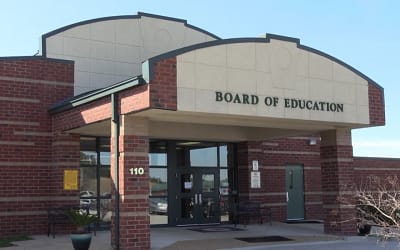
An important part of any school safety plan is to develop good working relationships with first responders before they’re needed during a potential emergency. Florida HB 301, which was enacted on July 1, 2023, was designed to make responses to crisis situations more effective.
The bill requires the Florida Department of Education to create a School Mapping Data Grant Program. According to the legislation, “Each school district, in consultation with local law enforcement and public safety agencies, may apply to receive funds from the program to provide school mapping data for each public school, including charter schools, in the district.”
In the event of a security threat, detailed school maps can provide first responders with immediate access to information about:
- floor plans
- exits
- entrances
- windows
- other points of access
According to federal guidance, emergency responders should “have advance information on where students, staff, and others with disabilities, as well as those with access and functional needs, are likely to be sheltering or escaping, generally in physically accessible locations, along accessible routes, or in specific classrooms.”
HB 301 includes a $14 million appropriation to fund bill compliance. According to estimates, a digital incident map can cost between $3,500 and $5,000 per school.
The bill also outlines minimum requirements for the data and instructs school systems to create maps in electronic or digital formats. The maps can assist first responders during emergencies at schools and active assailant drills.
Why is HB 301 Important?
According to The Washington Post, there were a record number of school shootings at K-12 schools in 2022. During 46 shootings, 34 students and adults were killed across the country.
In the wake of the tragedy at Marjory Stoneman Douglas High School, a public safety commission recommended that schools:
- Ensure all campus doors and buildings are clearly marked with easily identifiable markings.
- Mark exterior classroom windows so first responders can identify classrooms from outside of the building.
- Place building numbers on the roof for aerial support.
- Provide keys/access to on-duty law enforcement, so they can quickly enter the school.
Along with the use of other school safety devices, digital mapping of schools is another step toward safety and security for everyone on campus. It is an important update to previous practices. In the past, school systems have made maps available to first responders and other government officials, but unrolling a set of blueprints can cost precious seconds during a true emergency.
Because Florida’s School Mapping Data Grant Program mandates digital maps, first responders will have access to up-to-date information in real time during emergencies that they can access on:
- tablets
- smartphones
- laptops
According to HB 301, the digital school maps should mesh seamlessly with whatever software law enforcement agencies currently use. Law enforcement leadership will have the information they need at their fingertips, so they can direct officers exactly where they’re needed most. That means more people can be located and lives can be saved.

What is Required?
After the school system procures a vendor to provide the data, that entity “is responsible for providing the data to the school district and local law enforcement and public safety agencies for use in response to emergencies and for conducting drills,” according to the legislation.
Any maps created must be compatible with security software platforms that are already used in schools. There should be no fee or additional software needed for a school to make full use of the digital maps funded by the School Mapping Data Grant Program.
In addition, the program’s rules dictate that vendors are required to produce digital maps that match the software “used by local, state, and federal public safety agencies that provide emergency services to the specific school for which the data is provided without requiring such agencies to purchase additional software or requiring a fee to view or access the data.”
In order to ensure maximum effectiveness, the maps contain site-specific labeling of areas of the school, and all of the information should be verified for accuracy during a walkthrough of the school building and grounds.
Accurate floor plan data should be overlaid:
- on current aerial imagery
- with gridded x and y coordinates
All maps funded as part of HB 301 must be viewable on interactive mobile platforms. This turns smartphones and tablets into valuable school safety devices during crisis situations.
However, the legislation also requires that any maps created be available in an easily printable format, so first responders and school officials have as much flexibility as possible when using the information.
When a vendor is selected to perform mapping services, the company “is responsible for providing the data to the district and local law enforcement and public safety agencies.”

CENTEGIX Safety Blueprint
When it comes to keeping campuses safe across the country, CENTEGIX is dedicated to developing technology that empowers and protects people. The company’s Safety Blueprint provides a dynamic, multilayered map of all campus facilities and spaces. It was designed to optimize incident management, emergency response, and safety planning.
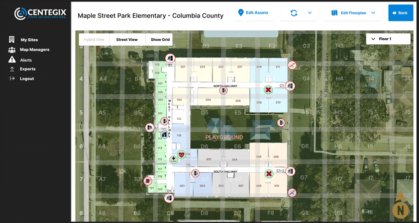
CENTEGIX’s proprietary technology delivers highly accurate digital mapping and gives users the ability to edit in multiple layers. It meets all requirements of Florida HB 301. The Safety Blueprint offers the security of:
- precise alert locations for responders
- a single map source for all software platforms
- the ability to assign roles to emergency responders
The technology also can be used to plan evacuations and reunifications, which are crucial to keeping students and staff members safe during different types of potentially threatening events.
In addition to providing valuable floor plan data, the maps can include the location of school safety devices, such as AEDs, fire alarms, first aid kits, fire extinguishers, and cameras. Those assets can have their own digital records, so school officials can be electronically notified of expiration dates.
Safety Blueprint can be easily updated without relying on the CENTEGIX teams. If there’s ever a change to a floor plan, school officials will be able to make changes to the core map that automatically will be reflected in all of the existing layers.
School districts may purchase Safety Blueprint as a stand-alone product, but it also can be used with other school safety devices, such as CENTEGIX’s CrisisAlert, a wearable panic button for incident response.
By using the two services together, schools can build direct links from classrooms to administrators to 911 dispatch. The technology can help schools manage everyday events as well as prevent, prepare for, and respond to extreme emergencies.
A Step Forward
The Florida House of Representatives passed HB 301 with a unanimous vote. That was followed by another unanimous vote in the Senate chamber, and Gov. Ron DeSantis signed it into law.
Clearly, the state’s leaders see the importance of providing law enforcement and other first responders with actionable information that has the potential to save lives during crisis situations.
The School Mapping Data Grant Program wouldn’t be necessary in an ideal world, but the reality is school leaders should do their best to prepare for the worst.
CENTEGIX is a national leader in developing innovative school safety devices that help keep students and staff members safe from potential threats. Click here to learn more about what we can do for you.