For IT Directors, school safety plans go beyond cyber security and network reliability. Investing in new safety technology that creates efficiency speeds emergency response time and can help other departments to collaborate and provide greater safety for all.
As technology evolves, IT managers have an opportunity to digitize and integrate security infrastructure and software in an effort to increase safety, reduce response times, and create a culture of safety. Thankfully, many states have created grants and earmarked funding to help schools invest in safety technology.
Dynamic Mapping Capabilities
Schools in states with mapping requirements must be able to share printable maps and digital maps that responders can use on their mobile devices in the field.
The maps must also situate an accurate school floor plan within the larger geographical area to help responders locate access points quickly.
Most school safety planning partners provide static mapping that can be downloaded for printing or sharing with law enforcement.
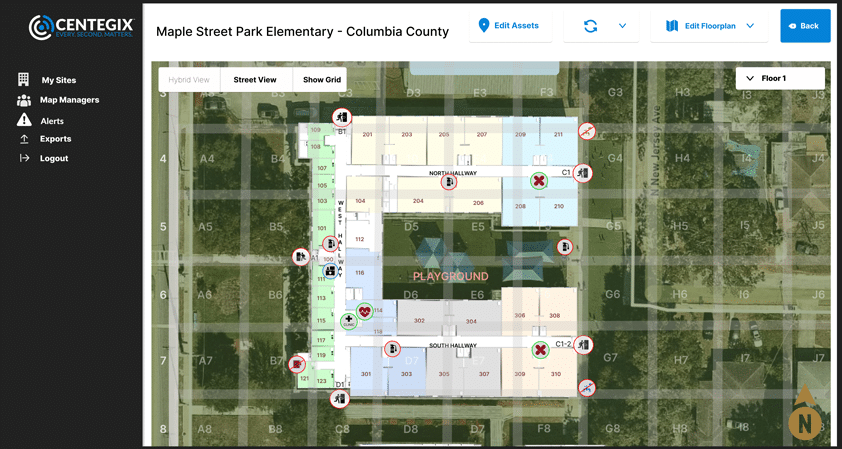
CENTEGIX’s mapping solution, Safety Blueprint™, overlays the school’s blueprint onto a constantly updating map, complete with multiple floors, description layers, and real-time CrisisAlert™ monitoring. When a silent alert is triggered, the CrisisAlert panel will show who triggered the alert and identify the location with a flashing strobe on the map.

Different Layers for Different Departments
The most robust dynamic mapping solutions offer school safety planners a way to visualize safety assets like fire extinguishers, AEDs, facilities, server rooms, network closets, biohazards, security equipment, and basic blueprint information all in one place. But navigating becomes difficult once all those assets are marked on a map.
CENTEGIX gives its users the ability to display assets by layer, including layers for safety assets, facilities, and IT assets.
Once a school chooses CENTEGIX as a partner in its school safety plan, the team builds a to-scale floor plan map of your facility and anchors it onto a satellite map that allows emergency planners and responders to navigate the surrounding areas using a satellite view or street-map view. School officials, emergency responders, and IT managers can then use the Safety Blueprint software to create assets on the map rendering.
Easy Updates in One Place
With a mapping solution, changes must be updated in each different system, both in your school and with law enforcement.
When you need to update safety equipment locations or make changes to the school’s overall floor plan, you don’t want to spend time making those changes in multiple systems.
With CENTEGIX Safety Blueprint, any updated assets are reflected across the entire CENTEGIX Safety Platform™ suite of solutions, which are immediately accessible by your emergency response agencies.
One-Stop School Safety Plan Compliance
While IT managers may be charged with vetting technology solutions and integrating data, required integrations reach beyond the IT department. IT managers must coordinate with existing technology providers, facilities, campus security, local law enforcement, state emergency response, and their own departments to collect all pertinent school safety plan information in one place.
But you don’t have to go it alone. Approved safety planning partners can help meet the many requirements on your state’s list of compliance items, and some can even serve as one-stop shops for all compliance needs.
CENTEGIX links silent alarm badge technology and dynamic mapping capabilities with the local and state emergency grid. Not only can CENTEGIX help achieve each area of compliance, but Safety Blueprint™ campus mapping and CrisisAlert™ mobile panic alerts integrate to give emergency responders real-time visual data, meaning the right help can arrive in the right place faster.
Emergency Services Grid Integration
Another common requirement in states with enhanced mapping regulations is to have the map on a geographic coordinate system grid.
School campuses and buildings are large, meaning a specific address or building isn’t always helpful for emergency responders working against time. Emergency responders need X and Y coordinates on a grid for precision location and faster response times.
Because CENTEGIX Safety Blueprint anchors the school map onto a satellite map, it is on the same grid system used by emergency responders.
Cost-Saving Compatibility
A school safety plan incorporates information from dozens of other locations, including additional software and technology systems. Switching providers mid-contract or investing in redundant systems can be considerable financial hurdles for budget-strapped schools to overcome.
IT managers must find a school safety plan solution that integrates with their current technology while meeting the school’s ultimate needs.
Grow Your Campus Without Reinvesting in Technology
A school investing in the safety of its students, teachers, and staff is a good school. And good schools grow.
Instead of investing in new safety technology, find a partner whose solutions can grow with you.
CENTEGIX offers its partners the ability to easily update its Safety Blueprint maps to accommodate renovations, portables, and even new buildings as your school changes.
Do You Need Help Reaching Compliance?
In an emergency, time is the most critical factor for a positive outcome.
Tighter safety regulations and increased safety funding benefit students, teachers, and staff, but compliance adds an additional hurdle for IT managers and school administrators.
CENTEGIX helps schools navigate the complex emergency management landscape with dynamic tools.
Our Safety Platform leverages dynamic digital mapping, real-time locating capabilities, an easy-to-use wearable panic button, and visitor management and reunification capabilities to plan for and respond faster to any safety situation.
Find out how CENTEGIX can be a one-stop shop for your school safety solutions, and then schedule a custom demo to see the CENTEGIX Safety Platform in action.


