CENTEGIX | Safety Blueprint
Emergency Response Mapping
Accurate, accessible maps accelerate emergency response
CENTEGIX | Safety Blueprint
Emergency Response Mapping
Accurate, accessible maps accelerate emergency response
What’s the need for digital school maps?
Digital school maps provide accurate campus layouts that assist first responders in an emergency.
Schools in states with mapping requirements must be able to share maps that responders can use from dispatch or on their mobile devices in the field.
The maps must also situate an accurate school floor plan within the larger geographical area to help responders locate access points quickly.
Most digital map vendors provide static maps that can be downloaded for printing or sharing with law enforcement.
A digital campus map only provides part of the picture
CENTEGIX Safety Platform combines emergency alert notifications with digital campus maps, and it always has.
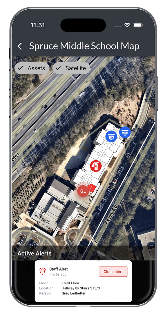
CENTEGIX’s mapping technology anchors the school’s blueprint to a satellite map that enables emergency planners and responders to navigate the surrounding areas using a satellite view or street-map view complete with a scaled grid overlay and true north orientation.
The dynamic maps offer visibility of multiple floors as well as the location of safety assets like fire extinguishers, AEDs, stop the bleed kits, access control points, server rooms, biohazards, security equipment, and basic blueprint information all in one place.real-time CrisisAlert™ monitoring. When a silent alert is triggered, the CrisisAlert panel will show who triggered the alert and identify the location with a flashing strobe on the map.
Knowing where emergency response is accelerates response
“If it’s not integrated with a crisis response system that can be pushed electronically to the dispatch center and police, then it’s probably not going to mean anything to them in the first minutes,” said Jeremy Gulley, the school system superintendent of Jay Schools Corp., Indiana.
CENTEGIX’s Safety Blueprint Provides the Location Detail for Rapid Emergency Response
- Knowing where an emergency is accelerates response detailed maps enable first responders to navigate quickly and mitigate harm.
- Outdated maps can do more harm than good updating digital maps can be done quickly and efficiently to reflect restructuring and the addition of safety assets like AEDs, lock boxes, cameras, access control and more.
- Maps aren’t helpful if they aren’t immediately accessible in an emergency. Digital maps help multiple units to collaborate on their response
- Maps should be shareable to promote a collaborative approach to school safety and a benefit to the greater community.

CENTEGIX Innovative Technology Delivers:
100% coverage of all indoor spaces and outdoor areas
Schedule a Demo to Learn How Mapping Can Help You Get Help Where It’s Needed, Immediately
Director of Safety & Security
Hillsborough County Schools
"*" indicates required fields

Empower Your Educators
with Safety
Explore More Safety Resources
Florida HB301: What is it? Why is it Important? What’s Required?
Texas Ahead of the Curve with New Bill: Texas HB3
Alyssa’s Law Supports Wearable Panic Buttons as Silent Panic Alert Solution
School Safety Standards by State
SOLUTIONS
INDUSTRIES
RESOURCES
COMPANY
PARTNERS
CONTACT
EVERY. SECOND. MATTERS.®


